Search
(+)
cartoon
dealer
buy stock illustrations
Home
My rookie portfolio
📷 Upload yours 🤳
Find results that contain
all
of your keywords. Content filter is
on
. Search will return
best illustrations, stock vectors and clipart
.
Exclude
Make it so!
You have chosen to exclude "
" from your results.
Choose orientation:
Explore cartoons & images using related keywords:
aloha
america
atlas
captain
cartography
chain
city
cook
federal
geography
globe
harbor
hawai
hawaii
hawi
hill
hilo
honokaa
honolulu
illustration
island
islands
kahoolawe
kailuaneelehu
kapaa
kauai
kaunakakai
kea
kekaha
kilauea
lanai
lihue
map
maui
mauna
molokai
mountain
niihau
oahu
ocean
pacific
pahala
pahoa
pearl
politically
polynesia
puuwai
red
state
states
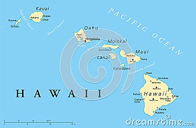
Hawaii Islands Political Map Vector Illustration
Download
Designed by
Peterhermesfurian
Title
Hawaii Islands Political Map #102544042
Description
Hawaii islands political map with capital Honolulu, most important cities and volcanoes. Illustration with English labeling and scaling. Vector.
State of Hawaii
Map of the U.S. state Hawaii
Hawaii islands map, USA, country, silhouette
Hawaii Islands map - state in the United States
Hawaii Islands. States of America territory on gray background. Separate state. Vector illustration
Hawaii Islands map - state in the United States
Hawaii Islands - US state. Territory in black color. Vector illustration. EPS 10
Grunge Hawaii Islands, USA Line Seal and Collage Worker Icon
Distress Hawaii Islands Line Seal with Collage Dollar Icon
Hawaii Islands In 3D Map
Simplified black silhouette of Hawaii islands border
Map silhouette of Hawaii islands with a fire in background