Search
(+)
cartoon
dealer
buy stock illustrations
Home
Black Friday
Find results that contain
all
of your keywords. Content filter is
on
. Search will return
best illustrations, stock vectors and clipart
.
Exclude
Make it so!
You have chosen to exclude "
" from your results.
Choose orientation:
Explore cartoons & images using related keywords:
africa
african
angola
atlas
benin
burundi
cameroon
cartography
central
chad
congo
equatorial
gabon
guinea
map
niger
nigeria
political
principe
republic
rwanda
sao
south
sudan
tanzania
tome
uganda
west
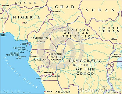
West Central Africa Political Map Vector Illustration
Download
Designed by
Peterhermesfurian
Title
West Central Africa Political Map #103024870
Description
West Central Africa Political Map with capitals, national borders, rivers and lakes. Illustration with English labeling and scaling.
North Africa and Middle East political map
West Central Africa countries political map
Cameroon flag and map - country wedged in West and Central Africa
Satellite map of Poznaà â, it is a city on the Warta River in west-central Poland. Map of streets and buildings
Vector city map of West Central London, UK
Flag of Cameroon. The official national flag of the Republic of Cameroon, a country in west-central Africa. Flat icon. texture map
Colorful map of Thailand with word north south west central, illustration on white background
South region. West South Central: Arkansas, Louisiana, Oklahoma, Texas. States of America territory. Separate states. Vector