Search
(+)
cartoon
dealer
buy stock illustrations
Home
My rookie portfolio
📷 Upload yours 🤳
Find results that contain
all
of your keywords. Content filter is
on
. Search will return
stock photos and royalty free images
.
Exclude
Make it so!
You have chosen to exclude "
" from your results.
Choose orientation:
Explore cartoons & images using related keywords:
aberdeen
architecture
building
castle
city
cityscape
edinburgh
europe
flag
glasgow
illustration
isolated
kingdom
landmark
map
panoramic
rooftop
scotland
sign
silhouette
skyline
subdivisions
tourism
tower
travel
united
urban
vector
Scotland Subdivisions Unitary Authorities Map And Scottish Largest Cities Skylines. All Elements Separated In Editable And Detac Vector Illustration
Download
Designed by
Jktu21
Title
Scotland subdivisions unitary authorities map and Scottish largest cities skylines. All elements separated in editable and detac #133340290
Description
Scotland subdivisions unitary authorities map and Scottish largest cities skylines. All elements separated in editable and detachable layers.
UK vector map with subdivisions
Map of Scotland with Subdivisions
Map of England
Map of East England
Map of South East England
Map of North East and West England
Map of Yorkshire and the Humber
Map of Scotland with Districts
Scotland higt detailed map with subdivisions. Administrative map of Scotland with districts and cities name, colored by states and
British Isles 3d (isometric) map colored by countries and subdivisions
United Kingdom isometric map colored by local government subdivisions and countries, with neighbouring countries on background
Scotland - political map of administrative divisions
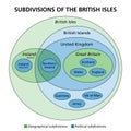
Subdivisions of the British Isles, Ireland and the UK, Euler diagram