Search
(+)
cartoon
dealer
buy stock illustrations
Home
My rookie portfolio
📷 Upload yours 🤳
Find results that contain
all
of your keywords. Content filter is
on
. Search will return
best illustrations, stock vectors and clipart
.
Exclude
Make it so!
You have chosen to exclude "
" from your results.
Choose orientation:
Explore cartoons & images using related keywords:
administrative
ardennes
arrondissement
aube
background
cartography
champagne
commune
country
county
department
detailed
district
est
europe
france
french
geography
grand
graphic
illustration
isolated
lorraine
map
marne
meuse
moselle
new
outline
plan
political
province
region
rhin
silhouette
subdivision
texture
topography
travel
vector
vosges
white
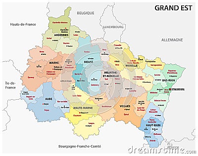
Administrative Map Of The New French Region Grand Est Cartoon Vector
Download
Designed by
Lesniewski
Title
Administrative map of the new french region grand est #136491023
Description
Administrative map of the new french region grand est.
Administrative and political map of the French overseas territory of Wallis and Futuna with flag
Administrative map of the new french region grand est with logo
Administrative map of the new french region Bourgogne-Franche-Comte
Administrative map of the new french region Hauts de France
Administrative vector map of the South American state of French Guiana
Administrative of the french and spanish part of the basque country with flag
Administrative vector map of the French region Provence-Alpes-Cote d`Azur with flag
Administrative vector map with flag of French region of Occitania
Administrative vector map with flag of French region of Normandie
Administrative map of the french cultural region Alsace
Administrative map of the French Mediterranean island of Corsica
Administrative vector map of the French city of Marseille
Administrative vector map of the southern French city of Toulouse