Search
(+)
cartoon
dealer
buy stock illustrations
Home
My rookie portfolio
📷 Upload yours 🤳
Find results that contain
all
of your keywords. Content filter is
on
. Search will return
best illustrations, stock vectors and clipart
.
Exclude
Make it so!
You have chosen to exclude "
" from your results.
Choose orientation:
Explore cartoons & images using related keywords:
administrative
aerial
america
atlas
background
border
borough
cartography
color
communication
country
design
detailed
district
division
evergreen
geography
global
highly
highway
illustration
map
name
northwest
ocean
olympia
outline
pacific
plan
political
region
road
seattle
silhouette
state
states
surface
terrain
territory
topography
track
traffic
travel
united
usa
vancouver
vector
view
washington
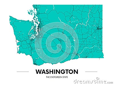
Detailed Washington State Map, Highly Detailed Territory And Road Plan, Vector Illustration
Download
Designed by
Max776
Title
Detailed Washington state map, highly detailed territory and road plan, vector illustration #186949525
Description
Detailed Washington state map, highly detailed territory and road plan, vector illustration for design
Washington D.C. vector street map
Vector posters with highly detailed silhouettes of maps of the states of America, Division Pacific - Washington, Oregon,
Vector posters detailed silhouettes maps of the states of America with abstract linear pattern, Division Pacific - Washington,
Detailed Washington Blind Map.
Detailed Washington physical map with labeling.
Detailed Washington physical map.
Detailed Washington physical map with labeling.
Detailed Washington physical map.
Detailed Washington road map with labeling.
Detailed Washington Silhouette map.
Detailed Washington road map with labeling.
Detailed Washington DC skyline vector illustration.
Large and detailed map of Washington County in Florida