Search
(+)
cartoon
dealer
buy stock illustrations
Home
My rookie portfolio
📷 Upload yours 🤳
Find results that contain
all
of your keywords. Content filter is
on
. Search will return
best illustrations, stock vectors and clipart
.
Exclude
Make it so!
You have chosen to exclude "
" from your results.
Choose orientation:
Explore cartoons & images using related keywords:
black
britain
cartography
county
england
europe
geographical
government
great
grey
ireland
kingdom
locations
map
northern
province
scotland
state
topography
united
vector
wales
white
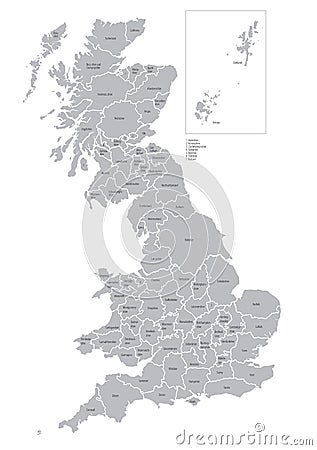
Map Of Counties Of Great Britain Vector Illustration
Download
Designed by
Poddubnygennady
Title
Map of counties of Great Britain #20359440
Description
Vectorial map of Great Britain with all counties. No gradients and blends. Every county is separate curve. Names of counties are in separate layers.
Blank map of England - counties
Vector map of United Kingdom administrative divisions colored by countries and regions. Districts and counties map of England, Wal
Vector posters with highly detailed silhouettes of maps of the states of America, The Great Lakes region - Minnesota, Wisconsin,
Political and administrative vector map of Great Britain
Highly detailed vector silhouettes of US state maps, Division United States into counties, political and geographic subdivisions
Political and administrative vector map of Great Britain
U.S. state of Wisconsin, subdivided into 72 counties, political map
U.S. state of Wisconsin, subdivided into 72 counties, gray political map
U.S. state of Michigan, subdivided into 83 counties, gray political map
Michigan, U.S. state, subdivided into 83 counties, multi colored map
Wisconsin, U.S. state, subdivided into 72 counties, multi colored map
A Vibrant and Dreamlike Visual Exploration of Great Britains Counties A Conceptual Map Art Photography
State of Michigan divided into counties, outline map
State of Wisconsin subdivided into 72 counties, outline map