Search
(+)
cartoon
dealer
buy stock illustrations
Home
My rookie portfolio
📷 Upload yours 🤳
Find results that contain
all
of your keywords. Content filter is
on
. Search will return
best illustrations, stock vectors and clipart
.
Exclude
Make it so!
You have chosen to exclude "
" from your results.
Choose orientation:
Explore cartoons & images using related keywords:
space
map
great
outline
geographic
coastline
eleuthera
caribbean
country
grand
city
world
tourism
commonwealth
sea
cuba
cartography
technology
graphic
island
capital
nassau
shape
abaco
bahama
travel
atlas
mayaguana
caicos
detailed
beach
geography
concept
territory
district
vector
province
america
background
cruise
design
illustration
english
geographical
north
andros
political
destination
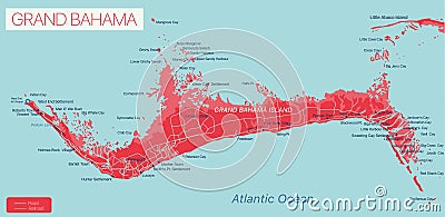
Grand Bahama Island Detailed Editable Map Vector Illustration
Download
Designed by
Olira
Title
Grand Bahama island detailed editable map #210655502
Description
Grand Bahama island detailed editable map, vector EPS-10 file
Greetings from Grand Bahama vintage rusty metal plate
Grand Bahama Island. Bahamas. Shape on white. Bilevel
Grand Bahama Island. Bahamas. Topo Humanitarian
Grand Bahama Island, Bahamas, cropped to square. Topo standard
Grand Bahama Island, Bahamas, cropped to square. Physical
Shape of Grand Bahama Island. Bahamas. Yellow
Grand Bahama Island, Bahamas, highlighted and labelled. Bilevel
Grand Bahama Island. Bahamas. Bilevel
Grand Bahama Island, Bahamas, cropped to square. Topo Humanitarian
Grand Bahama Island, Bahamas, cropped to square. Bilevel
Grand Bahama Island. Bahamas. Topo standard
Grand Bahama Island. Bahamas. Shape on white. Physical
Grand Bahama Island. Bahamas. Satellite, March 20, 2024
Grand Bahama Island, Bahamas, highlighted and labelled. Topo standard