Designed by
Title
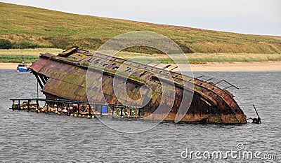
Sunken Boat at the Churchill Barrier, Orkney, Scotland, U.K. #21840126
Description
Sunken Boat at the Churchill Barrier, Orkney, Scotland, U.K. Churchill Sunk ship to stop the German Subs into Orkney in the 2nd world war. The Churchill Barriers are a series of four causeways in the Orkney Islands (at 58.8929ðN 2.8963ðW, 58.8820ðN 2.9028ðW, 58.8708ðN 2.9144ðW, and 58.8411ðN 2.9047ðW), with a total length of 2.3 kilometres (1.4 mi). They link the Orkney Mainland in the north to the island of South Ronaldsay via Burray and the two smaller islands of Lamb Holm and Glimps Holm. The barriers were built in the 1940s, primarily as naval defences to protect the anchorage at Scapa Flow, but now serve as road links. On 14 October 1939, the Royal Navy battleship HMS Royal Oak was sunk at her moorings within the natural harbour of Scapa Flow, by the German U-boat U-47 under the command of Günther Prien. U-47 had entered Scapa Flow through Holm Sound, one of several eastern entrances to Scapa Flow. The eastern passages were protected by measures including sunken blockships, booms and anti-submarine nets, but the U-47 entered at night at high tide by navigating between the blockships. To prevent further attacks, the First Lord of The Admiralty Winston Churchill ordered the construction of permanent barriers. Work began in May 1940 and the barriers were completed in September 1944 but were not officially opened until 12 May 1945, four days after the end of World War II The contract for building the barriers was awarded to Balfour Beatty,


