Search
(+)
cartoon
dealer
buy stock illustrations
Home
My rookie portfolio
📷 Upload yours 🤳
Find results that contain
all
of your keywords. Content filter is
on
. Search will return
best illustrations, stock vectors and clipart
.
Exclude
Make it so!
You have chosen to exclude "
" from your results.
Choose orientation:
Explore cartoons & images using related keywords:
aerial
continents
copernicus
desert
earth
gis
google
image
imagery
images
landsat
landscapes
map
maps
nature
observation
observed
pattern
photo
picture
planet
raster
remote
rivers
rst
sand
satellite
satellites
science
sea
seen
sensing
sensor
shape
sky
soil
space
system
top
view
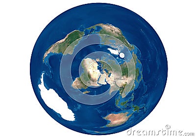
World Satellite Image With Continents Royalty-Free Stock Photography
Download
Designed by
Asvmagz
Title
World satellite image with continents #240406481
Description
Satellite image of the planet earth where all the continents are observed in the sea. contains modified data from google images
New technologies
High resolution world map and landforms
High resolution world map focused on Europe
Planet earth from the space at night
The Lena River, one of the largest rivers in the world.
Earth night view from space map with city lights satellite-based observations. `Elements of this image furnished by NASA
Earth flat view from space. Detailed World physical map on global satellite photo
Global connectivity concept with worldwide communication network connection lines around planet Earth viewed from space, satellite
World map with texture on global satellite photo, Earth view from space. Detailed flat map of continents and oceans
Space ship cosmos world. Generate Ai
Futuristic Space ship cosmos world. Generate Ai
Advanced Space ship cosmos world. Generate Ai
Physical map of the world, satellite view of the Middle East. Africa, Asia. Reliefs and oceans