Search
(+)
cartoon
dealer
buy stock illustrations
Home
My rookie portfolio
📷 Upload yours 🤳
Find results that contain
all
of your keywords. Content filter is
on
. Search will return
best illustrations, stock vectors and clipart
.
Exclude
Make it so!
You have chosen to exclude "
" from your results.
Choose orientation:
Explore cartoons & images using related keywords:
area
art
atlas
background
border
britain
british
britons
carte
cartography
coastlines
colour
colourful
commonwealth
country
county
culture
empire
england
english
europa
europe
european
geography
globe
great
icon
illustration
ireland
irish
island
isles
kingdom
london
map
maps
monarchy
northern
painting
post
postcode
postcodes
program
scotland
scottish
silhouette
south
southern
union
united
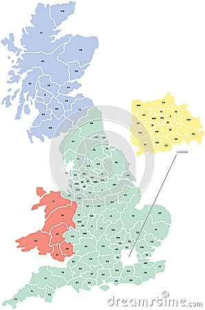
Postcode Map Of UK Vector Illustration
Download
Designed by
Gmashworth
Title
Postcode Map of UK #25081056
Description
A map of the UK with postcode areas identified and coloured, created within Adobe Illustrator CS2 and can be edited. Continent placed on a white background.
Vector illustration of mailbox
Personal information
Set of numerals
2-digit postcode areas Switzerland
Postcard highlighted the postcode, Introduction of Postal Code s
A spain province map with 2-digit zip codes
Black line icon for Postcode, poatal and email
United kingdom Postcodes or postal codes vector map
France 2 digit postcodes postal codes vector map
Black solid icon for Postcode, poatal and pincoad
Mix icon for Postcode, poatal and pincoad
Color illustration icon for Postcode, pincoad and poatal
Postcode icon of 3 types color, black and white, outline. Isolated vector sign symbol