Search
(+)
cartoon
dealer
buy stock illustrations
Home
My rookie portfolio
📷 Upload yours 🤳
Find results that contain
all
of your keywords. Content filter is
on
. Search will return
best illustrations, stock vectors and clipart
.
Exclude
Make it so!
You have chosen to exclude "
" from your results.
Choose orientation:
Explore cartoons & images using related keywords:
diagram
map
cartoon
pattern
state
boundaries
county
united
states
vector
shape
names
usa
maine
counties
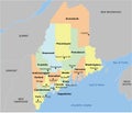
US Maine County Map Vector Illustration
Download
Designed by
Vectormaps
Title
US Maine county map #280697158
Description
US Maine county map with 16 countiesâ Names and Boundaries
Vector illustration of a county state with US united states flag
Maine County Map
Maine county maps
Franklin County, Maine U.S. county, United States of America, USA, U.S., US map vector illustration, scribble sketch Franklin
Hancock County, Maine U.S. county, United States of America, USA, U.S., US map vector illustration, scribble sketch Hancock
Kennebec County, Maine U.S. county, United States of America, USA, U.S., US map vector illustration, scribble sketch Kennebec
Lincoln County, Maine U.S. county, United States of America, USA, U.S., US map vector illustration, scribble sketch Lincoln
York County, Maine U.S. county, United States of America, USA, U.S., US map vector illustration, scribble sketch York map
Mount Desert Island in Hancock County Off the Coast of Maine Part of Acadia National Park WPA Poster Art
The Katahdin Woods and Waters National Monument in Northern Penobscot County Maine Including Section of East Branch Penobscot
Mount Katahdin Maine North Woods and River Flowing in Katahdin Woods and Waters National Monument Within Penobscot County Maine
Bass Harbor Head Light in Acadia National Park Hancock County Maine USA WPA Woodcut Black and White Art
County Maine Geob. France.
Pemaquid Point Light in Bristol Lincoln County Maine USA WPA Art Poster
Maine County Map with 16 counties