Search
(+)
cartoon
dealer
buy stock illustrations
Home
My rookie portfolio
📷 Upload yours 🤳
Find results that contain
all
of your keywords. Content filter is
on
. Search will return
best illustrations, stock vectors and clipart
.
Exclude
Make it so!
You have chosen to exclude "
" from your results.
Choose orientation:
Explore cartoons & images using related keywords:
christmas
island
australia
indian
ocean
asia
australasia
flying
fish
cove
settlement
anchorage
port
beach
sand
sun
resort
map
geography
cartography
vector
silhouette
border
travel
destination
city
country
road
background
outline
isolated
town
work
territory
region
atlas
drawing
contour
topography
national
capital
sign
sea
Christmas Island Highly Detailed Political Map Cartoon Vector
Download
Designed by
Bogdanserban
Title
Christmas Island highly detailed political map #301479117
Description
Highly detailed political vector map of Christmas Island with administrative regions and main cities
Snowman Santa Claus on a sandy tropical beach
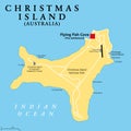
Christmas Island, external territory of Australia, political map
Christmas Island. Kiribati. Location diagram. Yellow
Christmas Island. Australia. Shape on white. Bilevel
Christmas Island. Kiribati. Shape on white. Bilevel
Christmas Island. Australia. Topo Humanitarian
Christmas Island. Kiribati. Topo Humanitarian
Christmas Island. Australia. Physical
Christmas Island. Kiribati. Physical
Shape of Christmas Island. Australia. Yellow
Shape of Christmas Island. Kiribati. Yellow
Christmas Island. Australia. Bilevel
Christmas Island. Kiribati. Bilevel
Christmas Island. Australia. Topo standard
Christmas Island. Kiribati. Topo standard
Christmas Island - Dotted Map. Map formed by Dots. Vector Illustration