Search
(+)
cartoon
dealer
buy stock illustrations
Home
Black Friday
Find results that contain
all
of your keywords. Content filter is
on
. Search will return
best illustrations, stock vectors and clipart
.
Exclude
Make it so!
You have chosen to exclude "
" from your results.
Choose orientation:
Explore cartoons & images using related keywords:
aegean
arctic
atlantic
atlas
austria
balkan
baltic
belarus
belgium
black
coastline
continent
country
croatia
czech
denmark
eurasia
europe
european
finland
france
germany
greece
hungary
ireland
island
italy
kingdom
map
mediterranean
netherlands
norway
ocean
peninsula
poland
political
republic
sea
spain
sweden
switzerland
travel
union
united
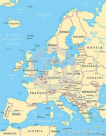
Europe Political Map Cartoon Vector
Download
Designed by
Peterhermesfurian
Title
Europe Political Map #50639739
Description
Europe Political Map and the surrounding region. With countries, capitals, national borders, big rivers and lakes. English labeling and scaling. Illustration.
Europe political map
Europe Political Map And Surrounding Region
Europe Political Map
Political blank map of Europe in white background.
Europe Political Map and Roads
Europe Political Map. Retro Colors and Bathymetry
Europe Political Map. Vintage Colors
Europe Political Map Outline
Europe Political Map Silhouette
Europe political map blue white card paper 3D
Political Physical Topographic Colored World Map Pacific Centered
Regions of Europe, political map, with single countries
Central Europe Political Map. No text
Central Europe Political Map
Northern Europe Political Map In Aqua Blue Colors