Search
(+)
cartoon
dealer
buy stock illustrations
Home
My rookie portfolio
📷 Upload yours 🤳
Find results that contain
all
of your keywords. Content filter is
on
. Search will return
best illustrations, stock vectors and clipart
.
Exclude
Make it so!
You have chosen to exclude "
" from your results.
Choose orientation:
Explore cartoons & images using related keywords:
abstract
airfield
alborean
atlas
bay
boundary
britain
british
cartography
coastline
europe
front
geography
gibraltar
great
iberian
illustration
lines
map
mediterranean
mole
neutral
north
oversea
peninsula
political
rock
sea
spain
strait
territory
travel
zone
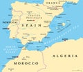
Gibraltar Political Map Vector Illustration
Download
Designed by
Peterhermesfurian
Title
Gibraltar Political Map #52338122
Description
Gibraltar Political Map of the British Oversea Territory. English labeling and scaling. Illustration.
Political map of Europe
Portugal and Spain political map
Morocco and Western Sahara political map
Gibraltar political map
Solid and Wire Frame Map of Gibraltar
Mosaic Gibraltar Map and Grunge Circle Seal
Vector Spectrum Dotted Map of Gibraltar
Gibraltar map of the British Oversea Territory. High detailed vector outline, blue silhouette and political map with spanish bo
Strait of Gibraltar, also known as Straits of Gibraltar, political map
Strait of Gibraltar, also Straits of Gibraltar, gray political map
Elections in Gibraltar
West Mediterranean, the Iberian Peninsula, gray political map
West Mediterranean, the Iberian Peninsula, political map
Costa del Sol, Spanish Riviera in Andalusia, south of Spain, political map
Costa del Sol, Spanish Riviera in Andalusia, gray political map