Search
(+)
cartoon
dealer
buy stock illustrations
Home
My rookie portfolio
📷 Upload yours 🤳
Find results that contain
all
of your keywords. Content filter is
on
. Search will return
best illustrations, stock vectors and clipart
.
Exclude
Make it so!
You have chosen to exclude "
" from your results.
Choose orientation:
Explore cartoons & images using related keywords:
aviv
background
banks
blue
boundries
boundry
colour
colours
computer
countries
country
east
fountain
gaza
generate
generated
golan
guide
height
heights
ierusalim
israel
jerusalem
jewish
judaism
lake
landscape
line
lines
map
middle
mission
model
mountains
neibourgh
occupied
orient
radar
region
regional
relief
sabbat
sabbatarian
sattelite
shadow
shape
shapes
shuttle
tel
territories
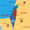
Israel And West Banks Map Vector Illustration
Download
Designed by
Emicristea
Title
Israel and West Banks map #5622210
Description
Israel and occupied territories (Golan Heights, West Banks and Gaza) political map in vector type.
Israel including Palestine - Gaza strip and West bank simplifi
City of Jenin in West Bank, Israel, vintage engraving
Woman from Beitin in West Bank, Israel, vintage engraving
vector map, flag, borders, mask , capital, area and population infographic
Map of the Dead Sea lying between Israel West Bank and Jordan
Map of Middle East - Israel with West Bank and Gaza
Lake Dead Sea State of Israel, West Bank map vector illustration, scribble sketch map
Lake Dead Sea (State of Israel, West Bank)
Israel map with labels including Gaza Strip and West Bank
Map of Israel, Gaza Strip, West Bank, Lebanon and Iran, Middle East
Israel country political map, including Golan Heights, West Bank and Gaza Strip. Detailed vector illustration with
Israel, gaza, west bank map, vector illustration.
Israel travel poster with dome of the rock and west wall ilistration