Search
(+)
cartoon
dealer
buy stock illustrations
Home
Black Friday
Find results that contain
all
of your keywords. Content filter is
on
. Search will return
best illustrations, stock vectors and clipart
.
Exclude
Make it so!
You have chosen to exclude "
" from your results.
Choose orientation:
Explore cartoons & images using related keywords:
alaska
america
atlantic
belize
canada
caribbean
cartography
colombia
continent
costa
cuba
dominican
geography
greenland
guatemala
haiti
honduras
iceland
illustration
jamaica
map
mexico
nicaragua
north
pacific
panama
physical
republic
rica
salvador
san
vector
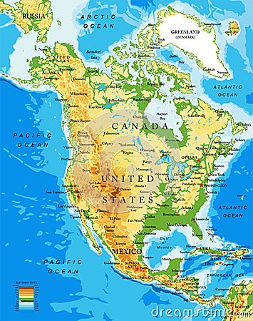
Physical Map Of North America Vector Illustration
Download
Designed by
Bogdanserban
Title
Physical map of North America #68694198
Description
Highly detailed physical map of North America,in vector format,with all the relief forms,countries and big cities.
Physical North america map
North America Physical Map. No text
Physical map of the world, Europe and North Africa. Globe. Hemisphere. Reliefs and oceans
High detailed North America physical map with labeling.
Physical map of the world, satellite view of Europe and North Africa. Night view. City lights. Globe. Hemisphere. Reliefs
Physical map of the world, satellite view of north and central America. Globe. Hemisphere. Reliefs and oceans
Physical map of the North Pole, Greenland. Reliefs and mountains. Bathymetry, underwater depth of ocean
Physical map of the eastern area of the Mediterranean Sea, states and borders, North Africa and the Middle East.
Physical earth map of North America
Physical earth map of North Pole
Physical map of USA, North America
Physical earth globe. North and South America
Physical map of North America, USA, Canada, Mexico and Central America
Physical earth globe. North and South America
This is a 3D illustration of a physical map of the planet Earth, focusing on North America, the USA, Canada, Mexico, and