Search
(+)
cartoon
dealer
buy stock illustrations
Home
My rookie portfolio
📷 Upload yours 🤳
Find results that contain
all
of your keywords. Content filter is
on
. Search will return
best illustrations, stock vectors and clipart
.
Exclude
Make it so!
You have chosen to exclude "
" from your results.
Choose orientation:
Explore cartoons & images using related keywords:
africa
america
arctic
asia
autumn
border
borders
boundaries
clima
climate
climatic
cold
college
countries
desert
deserts
detailed
details
dry
earth
edit
editable
education
equator
equatorial
europe
fall
frost
geographic
global
globe
heat
hot
humid
ice
map
oceania
planet
polar
pole
resolution
sahara
save
season
seasons
spring
states
summer
temperate
tropical
World Climate Zones Map Extremes Cartoon Vector
Download
Designed by
Ashestosky
Title
World climate zones map extremes #6987109
Description
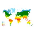
Vectorial and high resolution detailed map of the sub polar and tropical climates of the world
World climate zones info graphics
World of kids
Geography Map World Climate Details Concept
World map vector illustration
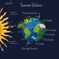
Summer solstice infographic with climate zones and day duration, and some cartoon summer symbols on the planet Earth.
World Climate Map with Temperature Zones
map with world climate zones
World climate zones map, vector geographic infographics
World climate change crisis or global warming alert, time to take care of our world environment concept, planet earth or globe
Global warming monochrome line icon set vector illustration. Collection logo world climate change
World climate zones
Global warming, world climate changing, ecology concept. Animals and environment in Antarctica in danger. Eco disaster
Globe is hovering on edge of precipice. Planet in danger. Apocalypse and catastrophe. End of world. Climate collapse and
Flat illustration of hand hold green earth globe with recycle symbol sustainability renewable energy effort save world climate