Search
(+)
cartoon
dealer
buy stock illustrations
Home
My rookie portfolio
📷 Upload yours 🤳
Find results that contain
all
of your keywords. Content filter is
on
. Search will return
best illustrations, stock vectors and clipart
.
Exclude
Make it so!
You have chosen to exclude "
" from your results.
Choose orientation:
Explore cartoons & images using related keywords:
america
art
background
border
canada
clip
color
concept
country
education
flag
geography
graphic
icon
illustration
image
isolated
land
map
modern
nation
north
politics
represented
shadow
sign
states
symbol
united
usa
vector
white
world
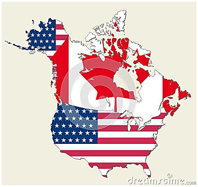
Map Of The States Of Canada And Usa Represented As Flag Cartoon Vector
Download
Designed by
Lesniewski
Title
Map of the states of canada and usa represented as flag #84865339
Description
Vector map of the states of canada and usa represented as flag
North America Map
Niagara Falls in United States / Canada. Flat cart
Survey map of the Canadian Atlantic States, Atlantic canada
USA and Canada large detailed political map with states, provinces and capital cities
Administrative and political vector map of the three North American states, Mexico, Canada and the United States of America
USMCA North America Trade
Black History Month celebrated in United States, Canada and Great Britain. Vector illustration design isolated on black background
Map of North America. Detailed map of North America with States of the USA and Provinces of Canada. Template.
Vector map of the Missouri River Drainage Basin, United States, Canada
Vector map of North American Lake Champlain, United States, Canada
Vector map of the alaska highway, united states, canada
United States, Canada and Mexico 3d (isometric) colorful map with states borders and names
Vector map of Lake St. Clair, United States, Canada
Planet earth rotating with night lights illuminating united states, canada and mexico