Search
(+)
cartoon
dealer
buy stock illustrations
Home
My rookie portfolio
📷 Upload yours 🤳
Find results that contain
all
of your keywords. Content filter is
on
. Search will return
stock photos and royalty free images
.
Exclude
Make it so!
You have chosen to exclude "
" from your results.
Choose orientation:
Explore cartoons & images using related keywords:
americas
antilles
atlas
background
basseterre
booby
capital
caribbean
cartography
christopher
commonwealth
country
cruise
destination
english
federation
geography
gray
illustration
indies
island
islands
isolated
kitts
labeling
leeward
lesser
map
nevis
political
saint
travel
vector
west
white
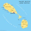
Saint Kitts And Nevis Political Map Vector Illustration
Download
Designed by
Peterhermesfurian
Title
Saint Kitts and Nevis political map #90367460
Description
Saint Kitts and Nevis political map with capital Basseterre. Federation of Saint Christopher and Nevis. Caribbean two-island country. Gray illustration on white background. English labeling. Vector.
Saint Kitts and Nevis Political Map
Berkeley Memorial Saint Kitts and Nevis vector flat attraction
Basseterre co-Cathedral Immaculate Conception Saint Kitts Nevis
Saint Kitts and Nevis country design Flat cartoon
Character from Saint Kitts and Nevis dressed in the traditional way for carnival
Saint Kitts, Nevis, Antigua, Barbuda and Montserrat political map
Saint Kitts, Nevis, Antigua, Barbuda, Montserrat political map
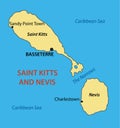
Federation of Saint Kitts and Nevis - vector map
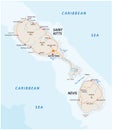
Saint kitts and nevis road vector map
Basseterre Linear City Skyline, Federation of Saint Kitts and Ne
Stamp or vintage emblem text Saint Kitts and Nevis, Discover the
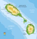
Saint Kitts and Nevis highly detailed physical map
Saint Kitts and Nevis Independence Day 19 September
Nieves Island. Saint Kitts and Nevis. Shape on white. Bilevel
Shape of Nieves Island. Saint Kitts and Nevis. Yellow