Search
(+)
cartoon
dealer
buy stock illustrations
Home
My rookie portfolio
📷 Upload yours 🤳
Find results that contain
all
of your keywords. Content filter is
on
. Search will return
best illustrations, stock vectors and clipart
.
Exclude
Make it so!
You have chosen to exclude "
" from your results.
Choose orientation:
Explore cartoons & images using related keywords:
administrative
argentina
cartography
country
del
fuego
geography
illustration
isolated
map
province
relief
shape
tierra
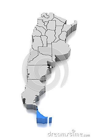
Map Of Tierra Del Fuego Province, Argentina. Stock Image
Download
Designed by
Cgracer
Title
Map of Tierra del Fuego Province, Argentina. #99243661
Description
Map of Tierra del Fuego Province, Argentina. 3d
Map of Tierra del Fuego Province, Argentina.
Tierra del Fuego province watercolor map of Argentina in front o
Tierra del Fuego map vector
Tierra del Fuego Province map
Map of Tierra del Fuego, archipelago at the southern tip of South America
3d isometric map of Tierra del Fuego is a province of Argentina
Tierra del Fuego National Park with Fagnano Lake Argentina WPA Art Deco Poster
Map of Tierra del Fuego, archipelago at the southern tip of South America
Tierra del Fuego archipelago, southernmost tip of South America, political map
Tierra del Fuego archipelago, southern tip of South America, gray political map
beaver dam on a track to laguna esmeralda in tierra del fuego AI-Created Content
Tierra del Fuego Island. Chile, Argentina. Physical
Tierra del Fuego Island, Chile, Argentina, cropped to square. Topo standard
Tierra del Fuego Island. Chile, Argentina. Topo standard
Tierra del Fuego outline map