Search
(+)
cartoon
dealer
buy stock illustrations
Home
My rookie portfolio
📷 Upload yours 🤳
Find results that contain
all
of your keywords. Content filter is
on
. Search will return
best illustrations, stock vectors and clipart
.
Exclude
Make it so!
You have chosen to exclude "
" from your results.
Choose orientation:
Explore cartoons & images using related keywords:
abstract
art
background
ben
big
border
britain
british
capital
cartography
color
colorful
continental
country
design
drawing
east
england
english
europe
flag
geography
graphic
great
humber
illustration
ireland
island
kingdom
land
london
map
midlands
national
north
northern
painting
part
political
province
region
scotland
south
symbol
territorial
territories
travel
united
vector
wales
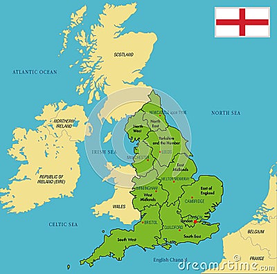
Political Map Of England With Regions And Their Capitals Vector Illustration
Download
Designed by
Zlatovlaska2008
Title
Political map of England with regions and their capitals #90875616
Description
Vector highly detailed political map of England with regions and their capitals. All elements are separated in editable layers clearly labeled. EPS 10
Colorful New England States administrative and political map
Political map of England with regions and their capitals
New England region of the United States of America, political map
New England region of the United States, gray political map
New England region of the United States of America, gray political map
United Kingdom countries and Ireland political map. England, Scotland, Wales, Northern Ireland, Guernsey, Isle of Man
Map of United Kingdom countries with the indication of Wales. Political map of England, Scotland, Wales, Northern Ireland and Isle
Map of United Kingdom countries with the indication of Northern Ireland. Political map of England, Scotland, Wales, Northern Irela
Map of United Kingdom countries with the indication of Scotland. Political map of England, Scotland, Wales, Northern Ireland and I
New England, a region of the United States, political map
New England, a region of the United States, gray political map
New England region of United States, political map
PostBrexit Britain Examining the Agricultural and Political Landscape of Rural England and its Impact on the UKs
Isle of Sheppey, England, political map